
Fájl:Tibet Karte Topograpisch.png
Az előnézet mérete: 800 × 540 képpont További felbontások: 320 × 216 képpont | 640 × 432 képpont | 1 024 × 691 képpont | 1 500 × 1 012 képpont.
Eredeti fájl (1 500 × 1 012 képpont, fájlméret: 3,08 MB, MIME-típus: image/png)
|
Ez a fájl a Wikimedia Commonsból származik. Az alább látható leírás az ottani dokumentációjának másolata. A Commons projekt szabad licencű kép- és multimédiatár. Segíts te is az építésében! |
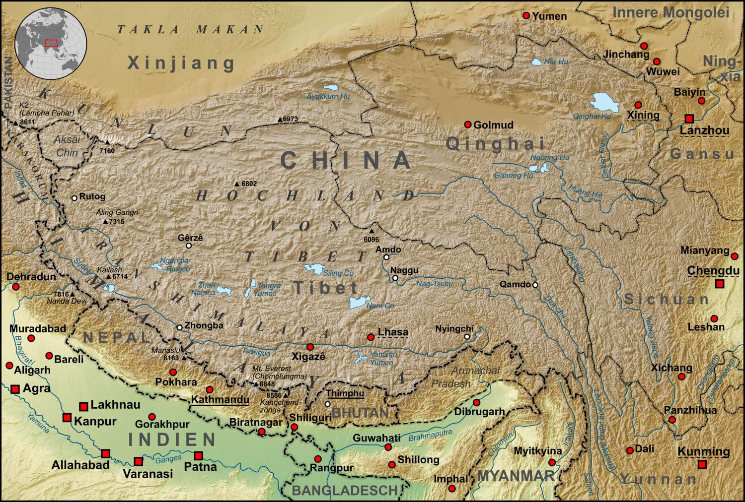
| Leírás | Topographische Karte der chinesischen autonomen Provinz Tibet, sowie der umliegenden chinesischen Provinzen und der angrenzenden Länder |
| Dátum | |
| Forrás |
own work, used:
|
| Szerző | Lencer |
| Más változatok | Származékos művek: ZabuyeLake1.png |
Ez a fájl a Creative Commons Nevezd meg! – Így add tovább! 3.0 Unported licenc alapján használható fel.
- A következőket teheted a művel:
- megoszthatod – szabadon másolhatod, terjesztheted, bemutathatod és előadhatod a művet
- feldolgozhatod – származékos műveket hozhatsz létre
- Az alábbi feltételekkel:
- Nevezd meg! – A szerzőt megfelelően fel kell tüntetned, hivatkozást kell létrehoznod a licencre és jelezned kell, ha a művön változtatást hajtottál végre. Ezt bármilyen észszerű módon megteheted, kivéve oly módon, ami azt sugallná hogy a jogosult támogat téged vagy a felhasználásod körülményeit.
- Így add tovább! – Ha megváltoztatod, átalakítod, feldolgozod ezt a művet, a közreműködésedet csak az eredetivel megegyező vagy hasonló licenc alatt terjesztheted.

|
Ezt a térképet a német Kartenwerkstatt készítette vagy javította. Te is javasolhatsz térképeket javításra.
|
Fájltörténet
Kattints egy időpontra, hogy a fájl akkori állapotát láthasd.
| Dátum/idő | Bélyegkép | Felbontás | Feltöltő | Megjegyzés | |
|---|---|---|---|---|---|
| aktuális | 2015. október 28., 08:30 | | 1 500 × 1 012 (3,08 MB) | Lencer | Ulugh Muztagh now 6973 m |
| 2015. október 28., 08:30 |  | 3 240 × 2 185 (12,63 MB) | Lencer | Ulugh Muztagh now 6973 m | |
| 2009. március 1., 15:11 |  | 1 500 × 1 012 (3,11 MB) | Lencer | Einige Korrekturen und Ergänzungen | |
| 2008. december 12., 23:22 |  | 1 500 × 1 012 (3,11 MB) | Lencer | {{Information |Description= |Source= |Date= |Author= |Permission= |other_versions= }} | |
| 2008. december 12., 10:18 |  | 1 500 × 1 012 (3,11 MB) | Lencer | {{Information |Description= |Source= |Date= |Author= |Permission= |other_versions= }} | |
| 2008. december 11., 14:57 |  | 1 500 × 1 012 (3,11 MB) | Lencer | {{Information |Description= |Source= |Date= |Author= |Permission= |other_versions= }} | |
| 2008. november 22., 14:13 |  | 1 500 × 1 012 (3,1 MB) | Lencer | {{Information |Description= |Source= |Date= |Author= |Permission= |other_versions= }} | |
| 2008. november 16., 16:46 |  | 1 500 × 1 012 (3,09 MB) | Lencer | {{Information| |Description=Topograhische Karte der chinesischen autonomen Provinz Tibet, sowie der umliegenden chinesischen Provinzen und der angrenzenden Länder |Source=own work, used: * Generic Mapping Tools and SRTM30-fi |
Fájlhasználat
Az alábbi lapok használják ezt a fájlt:
Globális fájlhasználat
A következő wikik használják ezt a fájlt:
- Használata itt: af.wikipedia.org
- Használata itt: ar.wikipedia.org
- Használata itt: ast.wikipedia.org
- Használata itt: az.wikipedia.org
- Használata itt: bo.wikipedia.org
- Használata itt: ca.wikipedia.org
- Használata itt: ceb.wikipedia.org
- Használata itt: ckb.wikipedia.org
- Használata itt: de.wikipedia.org
- Kunlun
- Transhimalaya
- Autonomes Gebiet Tibet
- Diskussion:Karakorum (Gebirge)
- Hochland von Tibet
- Benutzer:Lencer
- Benutzer:Lencer/Galerie
- Wikipedia:Kartenwerkstatt/Archiv/2008-12
- Diskussion:Transhimalaya
- Wikipedia Diskussion:Hauptseite/Artikel des Tages/Archiv/Vorschläge/2013/Q1
- Wikipedia:Hauptseite/Archiv/14. Februar 2013
- Tibet (1912–1951)
- Pinjarra-Orogen
- Tektonische Entwicklung des indischen Subkontinents
- Geologie des Transhimalayas
- Geologie der Indus-Yarlung suture zone
- Használata itt: el.wikipedia.org
- Használata itt: en.wikipedia.org
- Használata itt: eo.wikipedia.org
- Használata itt: es.wikipedia.org
- Használata itt: eu.wikipedia.org
- Használata itt: fi.wikipedia.org
- Használata itt: frr.wikipedia.org
- Használata itt: fr.wikipedia.org
- Használata itt: ga.wikipedia.org
- Használata itt: gl.wikipedia.org
- Használata itt: he.wikivoyage.org
- Használata itt: hi.wikipedia.org
- Használata itt: hy.wikipedia.org
- Használata itt: it.wikipedia.org
- Használata itt: ja.wikipedia.org
- Használata itt: ku.wikipedia.org
- Használata itt: lld.wikipedia.org
- Használata itt: lt.wikipedia.org
A fájl globális használatának megtekintése